Climate Change Impact - Part 4 - River Mekong (China, Thailand, Myanmar, Lao DPR, Vietnam)
Climate Change Impact
Part 4: Example – River Mekong
Summary
A component of a study of the impact
of climate change in Cambodia examined how flows in the Mekong River will
change in the future. Climate data on precipitation, temperature and other
climate variables were used as input to a hydrological model, HYSIM, of the
Mekong Basin. The model was calibrated to observed flows at six gauging
stations on the main river. The calibrated hydrological model was then used
with climate projections to estimate future flows in the River Mekong.
Introduction
The Mekong River Basin has a drainage area of 795,000 km2
and the river is 4350 km in length. The river rises in China at an elevation
5224 m. The river, or its tributaries, also flow through Myanmar, Laos, Thailand,
Cambodia and Vietnam. The river’s flow is highly seasonal, dictated by snow
melt in the upper reaches and by the Monsoon in the middle and lower reaches.
(At the point where the flow was simulated, Kompong Cham,
the basin area is 660,000 km2. It is interesting to compare this
with the smallest basin in this series simulated by HYSIM, Pago Stream in US
Samoa, which is only 1.52 km2.)
The primary objective of the project was to estimate the
impact of climate change on flooding of rural communities and of rural roads in
Cambodia. As part of this study a hydrological model of the Mekong River at a
daily time step was developed. The study
of the Mekong was necessary for two reasons. Firstly, for communities bordering
the river and secondly due its interaction with the inland lake of Tonle Sap.
 |
| Figure 1 Mekong River Basin |
Current climate
 |
Figure 2 Monthly average temperature - Mekong River Basin |
To estimate the impact of climate change it was decided to
simulate the flows of the Mekong using the HYSIM rainfall runoff model. This
model simulates the hydrological and hydraulic process in a river basin with a
high degree of physical realism. The model can operate at a daily or shorter
time step and in this case, it was decided to simulate the flows at a daily
time step. Given the very low temperatures in the upper basin the fact that
HYSIM can simulate snow accretion and snow melt was important. The input data
required are daily rainfall and daily or monthly potential evapotranspiration
(PET). The calculation of PET in turn requires data on temperature, humidity,
solar radiation and wind speed.
Thee data came from a variety of sources including:
·
The Ministry of Water Resources and Meteorology
of Cambodia - MOWRAM (Flow and climate for Cambodia.)
·
The National Climatic Data Center of the USA.
(Daily precipitation and temperature for the whole basin.)
·
The TuTiempo web site (Daily precipitation,
temperature, wind speed and relative humidity for the whole basin.)
·
The Climate Research Unit of the University of
East Anglia (average monthly values of temperature, relative humidity, wind
speed and solar radiation on a 10-minute grid for the whole basin.)
HYSIM has a number of built in data processing apps, these
included double-mass plots, infilling of gaps in the data series and the
calculation of PET.
Flow data for Cambodia came from MOWRAM and for the rest of
the basin from the Global Data Runoff Centre (GRDC).
Simulation
The first flow measuring station for which data were
available was for Chiang Saen, in Thailand immediately downstream of the border
with China. The total catchment area at this point is 186,000 km2. However,
given the large difference in climate in this part of the basin the catchment
was divided in three sub-catchments, each with its own climate data. The
following chart shows the simulated daily flow for the period 1988 to 1993
(1993 being the last year with flow data from GRDC site.)
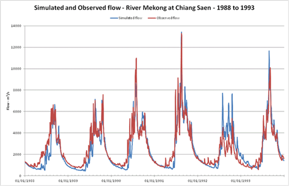 |
Figure 3 Simulated and observed flow at Chiang Saen
|
As can be seen, with the exception of 1992 when simulated
flows were too high, the simulation is generally accurate.
The simulation was continued downstream with intermediate
calibration points at Chiang Khan (Thailand), Mukdahan (Thailand), Pakse
(Laos), Stung Treng (Cambodia), Kratie (Cambodia) and Kampong Cham (Cambodia).
The following chart shows the flow simulation at Kampong Cham.
 |
| Figure 4 Simulated and observed flow at Kampong Cham |
For the site in Cambodia data had been ordered for 3 calendar
years, 2011 being the last. As can be seen the simulation is generally accurate.
There are, evidently, some small differences but given the limited data
availability the simulation can be considered satisfactory. There is no doubt
that had more time and data been available the simulation could have been
improved, in particular if major tributaries had been simulated.
It should also be recognised that the aim of the exercise
was to estimate the impact of climate change and the difference in flows.
Climate change
At the time when this study was carried out the latest
climate projections based on Representative Concentration Pathways were not
available. The earlier SRES projections were used. In this case, based on
earlier work in Cambodia, the ECHAM05 model with the A1B projection was used. This
option was chosen as the A1B scenario is considered to be the ‘business as
usual’ scenario which, given the absence of a successor to the Kyoto protocol
limiting CO2 emissions, was appropriate.
The precipitation and temperature were adjusted using
projected values of these two parameters. A second form of projection was
included based on the work of O’Gorman (Sensitivity of tropical precipitation
extremes to climate change. Geophysical Research Letters, published online: 16
September 2012). The paper quantifies the increase in intense precipitation
associated with an increase in temperature in the tropics. To use this
relationship the daily precipitation values for each calendar year were ranked and
the highest precipitation was increased by 10% for each degree of temperature
increase and the next two by 6%.
The following chart shows the change in average monthly flow
for the River Mekong at Stung Treng, the most upstream flow station in
Cambodia.
 |
| Figure 5 Projection change in monthly average flow - River Mekong at Stung Treng |
This chart shows that, on average, flows in the Mekong will
increase as a result of climate change. In particular the flood peak will be
higher.
The final chart shows daily simulation of observed flow for
the year with average flow, 1987, and projected flows adjusted to represent the
increases expected in 2050.
 |
| Figure 6 Projected (2050) and observed (1987) flow - Stung Treng |
Conclusion
The Mekong is one of the major rivers of the world. This
study showed it was possible to accurately simulate flows using data largely in
the public domain. When the hydrological model was used with climate
projections it was also possible to estimate future flows in the river.


Comments
Post a Comment