Glabal Sea Level Rise
Summary
- The average rate of sea level rise from 1880 to 2013 is 1.6 mm/year
- The rate of sea level rise is not constant. It is increasing at 0.014 mm/year/year.
- Superimposed on the rising sea levels is a cyclical component with a periodicity of about 50 years which is synchronous with the Atlantic Multidecadal Oscillation.
Sea levels have risen more than 100 m since the end of the last ice age and they are still rising. This post looks at the rate of rise over the last century or so and, based on sea level data, and answers the question "Is the rate of level rise increasing?",
The CSIRO provide one of the main estimate of global mean sea levels (Church, J. A. and N.J. White (2011), Sea-level rise from the late 19th to the early 21st Century. Surveys in Geophysics, doi:10.1007/s10712-011-9119-1.). The data run from 1880 to 2013. They are available as monthly or annual values. The annual values have been analysed here.
This chart shows the CSIRO sea level data. The data are in millimeters relative to an arbitrary datum. The data show that global sea levels have risen by just over 200 mm in the period 1880 to 2013. Plotting a trend line through the graph gives an average rate of rise of 1.6 mm/year. This is 160 mm century, much less than most of the climate change projections.

The above chart gives just one rate of sea level rise - the one for the whole period. So what if we look at year-on-year sea level change.
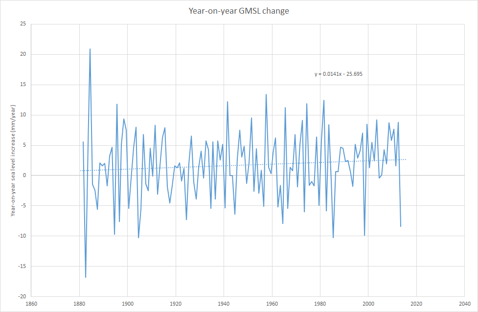
Year-on-year rate of sea level rise
The next chart plots the difference between the value of sea level in the given year and the value in previous year, for each year from 1981 to 2013. So, the first value is the difference between sea level in 1881 and in 1880, and so on. Looking at the chart there is a lot of year-to-year variation, from minus 17 mm/year to plus 21 mm/year. A trend line through the data shows that the rate of sea level rise has increased, by 0.0141 mm/year/year. That means the underlying rate of sea level rise was 1.9 mm/year higher in 2015 than it was in 1880. In other words, the rate of sea level rise is increasing.
Smoothed rate of sea level rise
One way of observing underlying trends more clearly when the data have a lot of year-on-year variation is to use a moving average. This takes the average of the values of the data for a number of years before and after each point plotted. As the data are so variable a long period has been used for averaging, 31 years. The first point plotted is for 1896 and is the average of the sea level from 1881 to 1911, the next is the average from 1882 to 1912 and so on.
This chart confirms that the rate of sea level rise is increasing but not in a uniform way. From a peak of 1.66 mm/year in 1900 to fell to minimum of 0.51 mm/year in 1920. It then rose to another peak of 2.2 mm/year in 1946 before falling to to a minimum of 1.33 mm/year in 1978. The rate of sea level rise then increased again to another peak of 2.84 mm/year 1997.
The trend line on the chart gives a slightly different value for the rate at which the rate of sea level rise in increasing, 0.0117 mm/year/year, to that in the chart above. This is due to effect of the averaging.

Cyclical component to sea level rise
The final chart plots the difference between the rate of sea level rise and the trend line. This is described as the detrended rate of sea level rise. For example, the peak in 1946 was 2.20 mm/year, the value on the trend line for that year was 1.63 mm/year so the value plotted was the difference between them 0.57 mm/year.
This chart shows that the rate of sea level rise has two components. The first is the underlying increase in the rate of sea level rise, this is 0.0141 mm/year/year as seen in the first chart. The second is a cyclical component with an amplitude of plus or minus 0.6 mm/year and a periodicity of around 50 years.

And the orange line? Climate scientists have detected a number of cycles in observed climate data. One of these is called the Atlantic Multidecadal Oscillation (AMO). It is based on sea temperatures in the northern part of the Atlantic Ocean. When the values of this oscillation are plotted along with the detrended rate of sea level rise they show a high degree of synchronicity. It cannot be argued that the AMO causes the variation in the rate of sea level rise. On other hand, it could be argued that both phenomena share an unknown forcing agent.


Comments
Post a Comment