Climate Change Impact - Part 2 - Southern Bangladesh
Climate Change Impact
Part 2: Example – Southern Bangladesh
Summary
This posting is based on a study of
the impact of climate change on Southern Bangladesh. It examines current
climate related problems which include storm rainfall, drought duration and sea
level rise. It concludes that the main changes in climate in the region will be
increases in temperature, storm rainfall, sea level and drought severity.
Average rainfall will remain similar to the present.
Introduction
The project area is shown in the following map. It covered 13
Upazilas in southern Bangladesh. The total population of the project areas was
17.6 million. In some Upazalis the population density was more than 1000 people
per square kilometre; about the average for Bangladesh.
 |
| Figure 1 Map of project area |
The project tackled three areas of vulnerability: roads, cyclone
shelters and markets. In terms of climate vulnerability, a significant factor
in the project area was the fact that much of the it was only a few metres
above mean sea level.
Current climate
Climate data were obtained from three main sources shown in
the following table.
Table 1
Sources of climate data used in report
Data source
|
Data
|
National Climatic Data Centre (part of the National Oceanographic and
Atmospheric Administration of the USA)
|
Daily values of rainfall, maximum and minimum temperature.
|
Climate Explorer, a site run by the Netherland Meteorological
Service.
|
Monthly values of temperature and rainfall.
|
TuTiempo, a weather site run by a Spanish company.
|
Daily values of temperature, rainfall, wind speed, atmospheric
pressure, relative humidity.
|
Other data analysed included sea levels (from the Permanent
Service for Mean Sea Level (PSMSL)) and Cyclone intensity (from the ‘Joint
Typhoon Warning Center’ web site.)
The observed climate data were analysed and some of the
conclusions were:
- Annual rainfall in the project area is reducing. For the period 1947 to 2015 the annual average is 2072 mm/year and it is falling by 1.3 mm each year.
- The monsoon rain, defined as the rainfall in the three wettest consecutive months in a year, is not decreasing.
- The monsoon season starts earlier with the wettest month being June in recent years but July in earlier years.
- The average temperature in the project area, based on the period 1890 to 2015, is 26.1 °C. It is increasing slowly and over the 125 years rose by 0.35 °C.
- Sea level data were obtained for 6 stations in the project area or from nearby sites in the Bay of Bengal. The data were downloaded from www.psmsl.org. Most sites had around 20 years of data but one had 60 years. The conclusion was that sea levels were rising at 4 mm a year but in places the settlement of the sediments in the delta gave an apparent increase of more than 10 mm a year.
- Data on cyclones were analysed for the Northern Indian Ocean, an area which encompasses the Bay of Bengal, using the Accumulated Cyclone Index. The data covered the period 1972 to 2014. It showed that cyclone energy was increasing by 1% a year – though there was a lot of inter-annual variability. Additional analysis of this data showed that the increase in energy was mainly related to an increasing number of storms – the energy in individual storms showed little increase. Cyclones are a major problem in the study area and in one incident it is estimated that 300,000 people were killed.
Climate projections
In many countries, you are given a lead as to where to go
for climate projections. For example, certain climate models might have been
shown to perform well or special models might have been developed. In the case
of Southern Bangladesh, I could find no such guidance. I therefore decided to
evaluate the accuracy of different climate models. In this case I established a
set of criteria related to both temperature and precipitation. For the period
of available data, the simulation of the climate models was compared to
observed values. The criteria included absolute values (some models are biased
having values which are consistently higher or lower than observed) and
relative values (based on trend and seasonal variation). There were 8 criteria
in all; temperature and precipitation, monthly and annual, bias corrected and
uncorrected.
From this analysis, a few points stood out:
- Average monthly values were more accurately simulated than annual time series.
- Temperature was more accurately simulated than precipitation.
- No model scored consistently higher than others on all criteria.
- Some models were highly rated for temperature or precipitation but poorly for the other one.
Four models were selected for more detailed analysis. These
were:
- NOAA GFDL-CM3, had the best average accuracy when all criteria were considered.
- MIROC-ESM-CHEM, was ranked 2nd overall.
- CESM1-CAM5, was ranked 5th overall. The model ranked 3rd was from the same source as model 1 and it was decided against using two models from the same source.
- MPI-ESM-LR, was ranked 6th based on all criteria but it was never lower then 11th on any criteria. This means it was less likely to produce a ‘bad’ projection.
The following chart shows the monthly simulated
and observed average temperature. Value for five models are shown – the four
retained as the best overall and the model which was best for this criterion. As can be seen all models performed well on this
criterion.
 |
| Figure 2 Observed and projected monthly temperature |
The next chart shows the simulated and observed annual
precipitation for the study area. This supports the statement above the annual
values and precipitation are not as accurately simulated as temperature.
 |
| Figure 4 Observed and projected annul precipitation |
For the projections, the highest value of RCP (RCP 8.5) was
used. There were two reasons for this. Firstly, as the value associated with
the maximum change in climate, it represents an outer envelope of projections.
Secondly, the lower values of RCP assume a more stringent agreement on
emissions than the ones achieved so far.
The next chart shows the projected change in average monthly
temperature for the period 2040-2060 relative to 1985-2015. Whilst there is a
range of projections, about 0.6 °C, the model are generally consistent in
projecting a lower temperature increase during the rainy season, May to
September, than for the rest of the year.
 |
| Figure 4 Projection of monthly temperature in 2050 |
The chart for annual precipitation shows much less
consistency among the models. For each model, there are two traces – a faint
one for annual values and a heavy one for the 10-year moving average. The range
of value suggest the change could be from minus 150 mm to plus 150 mm. For
comparison, the observed annual rainfall is around 2000 mm/year.
 |
| Figure 5 Projection of annual rainfall |
The projection of other parameters was also considered.
The same models were used for the projection on maximum
daily rainfall in each year (RX1 projection from the ETCCDI set). This showed that intense rainfall would
increase. All four models were consistent in projecting this increase. As the
precipitation is that for the whole area of the model cell which most closely
corresponded the study area, the difference in absolute values is likely to be
due to difference in model cell size.
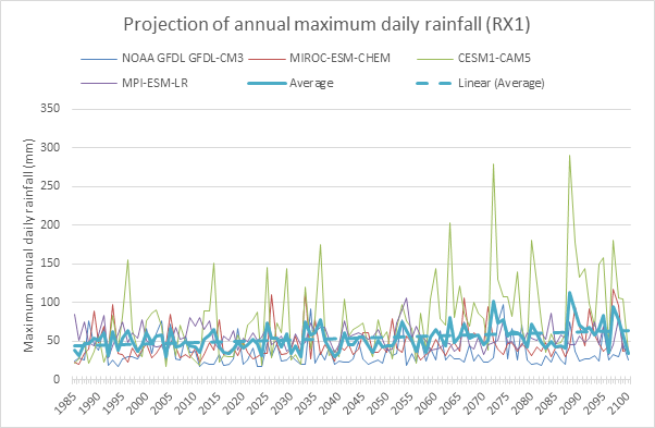 |
| Figure 6 Projection of annual maximum daily rainfall |
The study area is a rural area where agriculture is
important. To study the impact of climate change on agricultural productivity
the projections of projections of variables such as temperature, humidity and
others were used to calculate changes in potential evapotranspiration. These
values along with precipitation projections were used with a simple irrigation
model to show the change in water demand. This shows that annual water demand
is likely to increase from 600 mm/year to 800 mm/year for the mid-century
 |
| Figure 7 Projection of unsatisfied crop water demand |
Conclusions
The main changes in climate in the region will be increases
in temperature, storm rainfall, sea level and drought severity. Average
rainfall will remain similar to the present.


Comments
Post a Comment