The Canary in the Coal Mine
In days of yore, coal miners would take a caged canary into
the mine with them as the birds were more sensitive to poisonous gases than
humans; if the canary died then the miners got out – alive.
‘Climate sceptics’ have long accused ‘climate activists’ of
(to continue the metaphor) breeding highly sensitive canaries and looking for
dangerous coal mines. Up to now I’ve studiously respected this site's motto as
being a place where ‘numbers count’ and stayed out of debate. After a recent
paper on ‘vanishing islands’ in the Solomon Islands archipelago I felt I had to
comment. I was partly spurred on to do this by a guest post by David Middleton
on the wattsupwiththat.com web site.
The paper in question is “Interactions between sea-level
rise and wave exposure on reef island dynamics in the Solomon Islands” (Albert
et al, Environmental Research Letters, Volume 11, Number 5). The headline
message of the paper was
“..we present the first analysis of coastal dynamics from a
sea-level rise hotspot in the Solomon Islands [and] have identified five
vegetated reef islands that have vanished.”
That message got widespread coverage. At breakfast this
morning in my hotel in Dhaka (Bangladesh) a fellow guest (a curriculum
development specialist – nothing to do with climate) asked me if I had heard of
the seven (sic) islands which had disappeared.
The total land area of the Solomon Islands is 27,990 km2
(World Bank figure). The area of 5 islands which have disappeared is
given in the paper as 160,310 m2. Why did the authors use square
metres? Why not hectares or square kilometres? More usual surely for an island?
Perhaps it was because 160,310 m2 is 0.16 km2; that is
0.0006 % of the total area of the Solomon Islands.
OK. We are talking about canaries in coal mines so perhaps
they are justified in a little sleight of hand. Let’s look further.
Their introduction starts:
“How islands and the communities that inhabit them respond
to climate change and particularly sea-level rise is a critical issue for the
coming century. Small remote islands are viewed as particularly vulnerable.”
The authors do acknowledge a role for wave action but this is seen as secondary
to sea level rise.
The following table is taken from the paper.
Area (m2) of the 5 islands
which have disappeared
|
|||||
Island
|
1947
|
1962
|
2002
|
2011
|
2014
|
Kale
|
48,890
|
43,070
|
12,572
|
509
|
0
|
Rapita
|
45,700
|
21,250
|
0
|
0
|
0
|
Rehana
|
38,330
|
21,800
|
0
|
0
|
0
|
Kakatina
|
15,150
|
3,580
|
nd
|
0
|
0
|
Zollies
|
12,240
|
4,980
|
0
|
0
|
0
|
Total
|
160,310
|
94,680
|
12,572
|
509
|
0
|
What the table shows is that there was significant loss of
area between 1947 and 1962. The loss was
41% in that period. Expressed in m2 per year the rate was 4100 m2/year
for the period 1947 to 1962 and 1800 m2/year for the remainder of
the period. I recognise that defining two years just because they have data
might bias the answers but when the rate in the second period is less than half
that in the first period it is hard to accept that loss of island area is due
to increasing sea levels.
Let’s now take a look at sea level rise. The following chart
shows sea levels from two sources. The first is from the Permanent Service for
Mean Sea Level and covers the period 1975 to 2015. Levels were measured at two
locations with a short, 5-month, overlap. The second record from 1992 to the
present is from the University of Colorado Sea Level Research Group and is
based on satellite altimetry.

The PSMSL record has a rate of rise of 2.7 mm/year. The University
of Colorado gives a rate of 5.9 mm/year much less than 7 mm/year quoted in the
paper; the difference in rate is in part probably linked to the recent drop in
sea levels due to the El Nino effect. One drawback of these data is that they
do not cover the whole period 1947 to the present used for analysis of the area
of the islands.
In January of this year I was in Samoa – looking at the
impact of climate change on roads. There it is something to be concerned about.
On both of the two main islands there are few inland roads but they do have roads
all the way round each of the islands. In places these roads are on a narrow
coastal band and barely above the current high tide level. So, a modest
increase over the next decade or so could have serious consequences. While
there I prepared estimates of sea levels from 1948 to 2014. These, together
with the PSMSL figure for Solomon Islands are shown on the next chart.
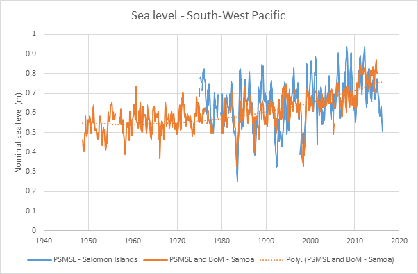
The amplitude of the sea level estimates is higher for the
Solomon Islands than for Samoa but they show a similar trend. I’ve also plotted
a quadratic trend line through the Samoa data when shows that for the early
period sea levels were more-or-less constant but in recent decades have been
rising more rapidly.
In other words, if sea levels in the Solomon Islands have
followed a similar trend to Samoa, the most rapid loss of area coincided with
the least change in sea level.
I mentioned above that I am working in Bangladesh. At the
northern end of the Bay of Bengal the 2 metre contour is 100 km from the coast.
A typical spring tide has a range of 4 metres. In that part of the country most
agricultural land is behind embanked polders and when they are overtopped the
land becomes saline. So creeping sea level rise has a real impact there.
The paper that is the basis of this posting has, of course,
succeeded in the author’s terms; it has got wide publicity for the potential
impact of climate change. But whether describing the disappearance of five
small islands, whose total area is that of 20 soccer pitches, has advanced
climate science is a moot point.


Comments
Post a Comment